 United States: divided on the question of presidential immunity, the Supreme Court offers respite to Trump
 Maurizio Molinari: “the Scurati affair, a European injury”
 Hamas-Israel war: US begins construction of pier in Gaza
 Israel prepares to attack Rafah
 Spain is the country in the European Union with the most overqualified workers for their jobs
 Parvovirus alert, the “fifth disease” of children which has already caused the death of five babies in 2024
 Colorectal cancer: what to watch out for in those under 50
 H5N1 virus: traces detected in pasteurized milk in the United States
 Private clinics announce a strike with “total suspension” of their activities, including emergencies, from June 3 to 5
 The Lagardère group wants to accentuate “synergies” with Vivendi, its new owner
 The iconic tennis video game “Top Spin” returns after 13 years of absence
 Three Stellantis automobile factories shut down due to supplier strike
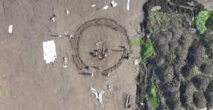 A pre-Roman necropolis discovered in Italy during archaeological excavations
 Searches in Guadeloupe for an investigation into the memorial dedicated to the history of slavery
 Aya Nakamura in Olympic form a few hours before the Flames ceremony
 Psychiatrist Raphaël Gaillard elected to the French Academy
 Skoda Kodiaq 2024: a 'beast' plug-in hybrid SUV
 Tesla launches a new Model Y with 600 km of autonomy at a "more accessible price"
 The 10 best-selling cars in March 2024 in Spain: sales fall due to Easter
 A private jet company buys more than 100 flying cars
 This is how housing prices have changed in Spain in the last decade
 The home mortgage firm drops 10% in January and interest soars to 3.46%
 The jewel of the Rocío de Nagüeles urbanization: a dream villa in Marbella
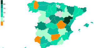 Rental prices grow by 7.3% in February: where does it go up and where does it go down?
 Even on a mission for NATO, the Charles-de-Gaulle remains under French control, Lecornu responds to Mélenchon
 “Deadly Europe”, “economic decline”, immigration… What to remember from Emmanuel Macron’s speech at the Sorbonne
 Sale of Biogaran: The Republicans write to Emmanuel Macron
 Europeans: “All those who claim that we don’t need Europe are liars”, criticizes Bayrou
 These French cities that will boycott the World Cup in Qatar
 Archery: everything you need to know about the sport
 Handball: “We collapsed”, regrets Nikola Karabatic after PSG-Barcelona
 Tennis: smash, drop shot, slide... Nadal's best points for his return to Madrid (video)
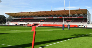 Pro D2: Biarritz wins a significant success in Agen and takes another step towards maintaining
Last night, the calendar began in the spring. And it is almost forgotten how unusual the last Winter was at times. On the Northern side of the Alps it was in January, so cold as in 30 years, while it was in some regions on the South side of the Alps as mild as never before in 150 years.
the North winds brought in the first half of January continued cold and moist air in Switzerland. They dammed up at the Alps, so that in the East of Switzerland and the Gotthard region within three days, record amounts of snow fell. On the South side of the Alps, however, a mild Nordföhn swept through the southern valleys.
February, then, was quite different: He was one of Switzerland to the ten mildest February-months since the start of the measurements. On the Jungfraujoch, the average monthly temperature rose five degrees above the Norm. The reason for a persistent high-pressure weather with an unusual amount of sunshine.
cooling
It is a Reflex that, according to special events questions are asked. The tourism industry wants to know, for example, with the expected winter climate in the future. The Winter are due to climate change, but it is not warmer? It is to be expected with more snow than expected? The explanations for it are many. The scientists, nevertheless, say reluctant with before.
In Switzerland, you realize since 1990, in the Winter, a slight cooling in the mountains. For ETH-Zurich climate researcher Reto Knutti, the coincidence may be. "Trends over 30 years are not very meaningful, the planetary air circulation changed dramatically," he says. It is mainly responsible for the direction from which the winds reach Switzerland.
the origin of The air is crucial to how cold it is in the mountains and in the Mediterranean country in our country. This means that The temperature in the Winter is mainly from the frequency of cold air, weather dependent. The investigation of Meteo Switzerland. So there were, for example, persistent North-West winds, which brought mid-January, moist polar air in our country and for the enormous amount of snow. The statistics of the last 50 years, however, shows no increase in the frequency of such weather conditions. "It is still unclear why the atmosphere surrounded your winter flow regimes over Europe and strong again," says Stephan Bader, a climatologist at Meteo Suisse.
accumulation of cold Winter?
those Who want to explore the development of the winter temperature, of the need to distinguish. In the last 25 years, it has become, as I said, on the Northern side of the Alps a little cooler. In the long term, however, different. "The Winter in Europe in the last hundred years warmer," says Reto Knutti.
But the closes are not, in the future, cold and snowy Winter in the mid-Latitudes, piling. On The Contrary. There are several possible causes: For example, a change in the planetary circulation of the air flows better under the name of Jetstream known. These winds mainly determine the daily weather. You lose energy, they start to wobble. It is like a river that carries little water, and therefore large loops in the river bed begins. Slippage means in the jargon.
This phenomenon can be observed in the Jetstream, if the temperature difference between the cold air over the Arctic and the milder in the South is lower. This is the case if the Arctic is warming. As a result of climate change in the polar region happens in comparison to the global development twice as fast. This has to do with that because of the enormous Melting of the Arctic sea ice, less solar radiation is reflected. The Arctic ocean is warming up. This in turn speeds up the melting process.
theory
The theory of scientists is, therefore, plausible: The Arctic warming has consequences on the circulation pattern of the atmosphere, and therefore on the weather development in Europe, North America and Asia. This connection meteorologists have already seen the beginning of the 20th century. Century. It has been decades passed, however, until the exploration of these relationships has been intensified – until 2007, the Arctic lost dramatically to the sea ice.
US Researchers at the Rutgers University came up with the Theory that the jet stream is slowed down by the rapid Arctic warming and, therefore, the air flow more easily distracted – for example by temperature fluctuations in the sea water or by the mountain chains. The probability for strong meandering Jet stream would grow. The consequence: More warm air is transported to the North, cold in the South. Due to the slowdown in the Jet stream can certain weather patterns persist. In the summer, for example, a stationary high-pressure areas, such as 2003, or last summer, leading to heat waves. With other words: The climatic development in the North decides on extreme events in our Latitudes.
In the winter months, however, it is more difficult, long-lasting to identify locations and weather. A research group Knutti trying to figure out whether or not certain weather stopping constellations in the Winter in the future than in the past, when terms of climate protection by the end of the century, done nothing, and the earth would warm more than 3 degrees. The yet unpublished results show that The climate models up to the year 2100 generally no Trend.
Quick heating
"There are various effects in the atmosphere play a role and may influence each other", says Daniela Domeisen from the Institute for atmospheric and climate at the ETH Zurich. It deals with atmospheric phenomena and their prediction. This includes the polar vortex over the Arctic, in the winter season, when only a little light reached the Region in the stratosphere at an altitude between 15 and 50 kilometres.
at the beginning of January has warmed the stratosphere by inflowing warmer air very quickly, and the vortex is broken into two parts. In such a case, cold Arctic air can opt-out to the South in the mid-Latitudes. The weather conditions will be benefited from this phenomenon, can persist for weeks. This year's extreme cold in North America, meteorologists are, as a result of this effect. "Europe was, however, affected this Winter, less of it," says Domeisen. In contrast to last Winter. Since the end of February 2018 because of such an event in the stratosphere on a generally warm Winter, a prolonged Cold snap.
About a quarter of such cold air intrusions can be attributed to this stratospheric Warming, says Domeisen. Model calculations to date show no Trend towards an increase in this phenomenon. The appearance is only since the 50s is known, the data series are therefore too short. "In the 1990s, only two of such phenomena occurred in the 2000s, there were nine," says atmospheric physicist.
Even if in the Winter, and the global circulation of many is uncertain. "It is clear that a shift in the Jet stream poleward takes place as a result of climate change," says Domeisen. And ETH climate researcher Reto Knutti warns us to beware of hasty conclusions: "The warming due to more CO2 is not in dispute. Who is the Winter dependent on doing for the time being, the fact to be reckoned with even warmer temperatures and less snow."
(editing Tamedia)
Created: 20.03.2019, 18:33 PM