 War in Ukraine: when kyiv attacks Russia with inflatable balloons loaded with explosives
 United States: divided on the question of presidential immunity, the Supreme Court offers respite to Trump
 Maurizio Molinari: “the Scurati affair, a European injury”
 Hamas-Israel war: US begins construction of pier in Gaza
 First three cases of “native” cholera confirmed in Mayotte
 Meningitis: compulsory vaccination for babies will be extended in 2025
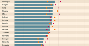 Spain is the country in the European Union with the most overqualified workers for their jobs
 Parvovirus alert, the “fifth disease” of children which has already caused the death of five babies in 2024
 Inflation rebounds in March in the United States, a few days before the Fed meeting
 Video games: Blizzard cancels Blizzcon 2024, its annual high mass
 Falling wings of the Moulin Rouge: who will pay for the repairs?
 “You don’t sell a company like that”: Roland Lescure “annoyed” by the prospect of a sale of Biogaran
 Exhibition: in Deauville, Zao Wou-Ki, beauty in all things
 Dak’art, the most important biennial of African art, postponed due to lack of funding
 In Deadpool and Wolverine, Ryan and Hugh Jackman explore the depths of the Marvel multiverse
 Tom Cruise returns to Paris for the filming of Mission Impossible 8
 Skoda Kodiaq 2024: a 'beast' plug-in hybrid SUV
 Tesla launches a new Model Y with 600 km of autonomy at a "more accessible price"
 The 10 best-selling cars in March 2024 in Spain: sales fall due to Easter
 A private jet company buys more than 100 flying cars
 This is how housing prices have changed in Spain in the last decade
 The home mortgage firm drops 10% in January and interest soars to 3.46%
 The jewel of the Rocío de Nagüeles urbanization: a dream villa in Marbella
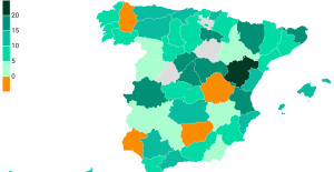 Rental prices grow by 7.3% in February: where does it go up and where does it go down?
 Even on a mission for NATO, the Charles-de-Gaulle remains under French control, Lecornu responds to Mélenchon
 “Deadly Europe”, “economic decline”, immigration… What to remember from Emmanuel Macron’s speech at the Sorbonne
 Sale of Biogaran: The Republicans write to Emmanuel Macron
 Europeans: “All those who claim that we don’t need Europe are liars”, criticizes Bayrou
 These French cities that will boycott the World Cup in Qatar
 Basketball: Strasbourg appeals the victory recovered by Monaco
 Top 14: UBB with Tatafu and Moefana against Bayonne
 MotoGP: Bagnaia dominates qualifying practice in Spain and sets track record
 Olympic Games: in Athens, Greece transmits the Olympic flame to France
the Calendar shows mid-July and yet the weather associations with the poor spring weather.
How is it going to be just yet, points to the duty officer at the Danish Meteorological Institute.
A high pressure over The British Isles moving east and southeast, and it means that the week will be a little warmer than the past week. But from Tuesday is expected new fronts to cross the country from the west with the stable weather.
on Sunday we can get occasional bursts that can hit most of the country. And the week also comes to bear the mark of to be to the cool side with a cold front, which comes on the night of Tuesday, says Erik Hansen of DMI.
Monday will be exactly by the book to be a bit of a mediocre day, when a western wind is blowing hard into that, however, decreases and becomes easy to fresh.
The many clouds will have an influence on the temperatures, not clings up over 20 degrees. Especially in the north of Jutland, it will be possible with an entire rainy day, but otherwise more or less free.
Finally something happens from Thursdays, where the clouds will appear patchy, which will a few degrees to move upward as a high pressure will approach from the west.
- It may well be that you can jump in the water, and it looks like perfect beach weather, but there will be gales around the coasts. Around 22-24 degrees, we can reach, when the week is coming to an end, says Erik Hansen.
Cool summer weather, which suits to the active life, waiting for us today. A little windy, but only a few showers and the temp. at 15-18 degrees. What with kite-flying, jogging or camping with campfire bread over the campfire? To see the weather for your location on the https://t.co/DbJDTyCXDH pic.twitter.com/okiRP5LFgJ
— DMI (@dmidk) July 12, 2020